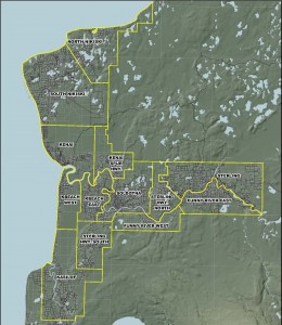
 CARTS serves the cities of Soldotna and Kenai, and the communities of Kasilof, Nikiski and Sterling and all points in between.
The central Kenai Peninsula is split in to thirteen zones, and passengers are charged according to the number of zones they travel through.
*Note: The information depicted in this map is for a graphical representation only and may not be exact. For more information contact the CARTS office.
The boundaries of the zones are:
| Funny River Road East | Mile 8 to the end of the road |
| Funny River Road West | Soldotna City limits to mile 8 |
| Kasilof | Irish Hills to North Cohoe |
| KBeach East | College Loop to Bridge Access |
| KBeach West | Bridge Access to Mile 8 KBeach |
| Kenai | 4 – Lane to Mile 15 |
| Kenai Spur Highway | Kenai Auto to 4 – Lane |
| Sterling | Bings Landing to Whisper Lake |
| Sterling Highway North | Whisper Lake to Boundary Street |
| Sterling Highway South | Skyview to Irish Hills |
| Soldotna | Boundary Street to College Loop |
| North Nikiski | Mile 29 to end of road |
| South Nikiski | Mile 15 to Mile 29 |
*Note: The information listed above is for descriptive purposes only and may not be exact. For more information contact the CARTS office.